The Met Office has issued new weather warnings for parts of the UK, as temperatures are forecast to drop sharply towards the end of this week. Over the coming days, the UK will continue to experience further spells of wet and at times windy weather, but a significant change is expected later in the week with colder air moving south across the country.
Impact on Travel and Daily Life
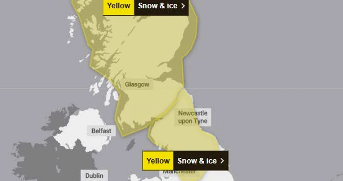
By Friday, many areas will see a sharp drop in temperatures, increasing the risk of snow, particularly over higher ground in Scotland, northern England, and parts of Wales. The Met Office has issued a yellow alert for snow and ice, covering much of the UK on Thursday, February 12, from 4pm until 12am on Friday, February 13.
The warning states that snow showers and icy roads could lead to some travel disruption. Affected areas include Scotland, Derbyshire, parts of North East and North West England, Staffordshire, and Yorkshire and Humber. The forecast indicates that outbreaks of rain will fall as snow over higher hills initially, before snow begins to fall to lower levels through Thursday evening.
Any settling snow will mainly be confined to high ground, above 200 metres, with 2 to 5 cm of snow possible, and above 300 metres, a few locations may see as much as 10 cm. The rain and snow are expected to clear south during the early hours of Friday, with temperatures expected to fall quickly as skies clear, leading to ice on untreated surfaces.
Met Office Guidance for the Public
The Met Office has issued guidance to the public, warning that snowy and wintry weather can cause delays and make driving conditions dangerous. It recommends that people plan their routes carefully, give themselves extra time for their journey, and check for road closures or delays to public transport, amending plans if necessary.
Residents are also advised to stay updated with the latest weather forecast in their area, as weather warnings can change rapidly. The Met Office has emphasized the importance of preparedness, particularly as colder temperatures and potential snowfall could impact daily routines and travel plans.
Regional Weather Outlook
Merseyside is not under a weather warning, but the region is expected to experience colder temperatures. According to the BBC’s weather forecast, this afternoon and evening will be cloudy and breezy, with spells of rain pushing in from the east throughout the day. Tonight will remain cloudy and damp, with spells of rain continuing, generally turning lighter and a little patchier through the night.
Looking ahead to tomorrow, the forecast suggests a chillier day, with cloudy conditions and patchy light rain moving in at times throughout the day, accompanied by gentle winds. The Met Office has also noted that relentless rain has prompted flood warnings and alerts across the country over the past few days.
In its long-range forecast from Sunday, February 15, to February 24, the Met Office said that showers or longer spells of rain are expected as Atlantic low-pressure systems dominate in the vicinity of the UK. Some heavy rain is likely in places, probably focused on western hills, with some snow at times in the north, mainly on high ground. Strong winds are possible at times, especially around coasts, with temperatures expected to remain near normal.
Towards the end of next week, the weather forecast suggests that the long-standing blocked pattern, which has kept low-pressure systems lingering to the west and unable to move eastwards, finally begins to break down. As this happens, colder air is expected to sink further south across the UK.
The Met Office said that by Friday, the colder air mass will become more dominant, with temperatures falling below average across much of the UK. Many areas will feel a stark contrast compared to the mild start earlier in the week. As freezing levels drop, precipitation increasingly turns to snow, initially over higher ground in Scotland but potentially reaching lower levels later in the day.
The high ground of north Wales and northern England may also see accumulating snowfall by Friday evening. This shift in weather conditions is expected to have a significant impact on travel, infrastructure, and daily life across the country.


Comments
No comments yet
Be the first to share your thoughts