

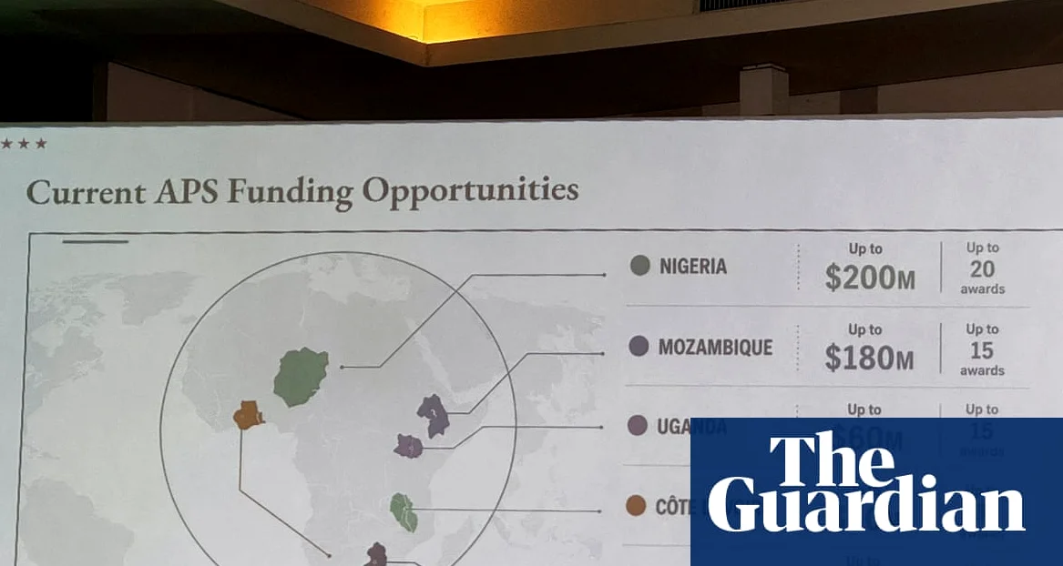
The U.S. State Department issued an apology after a map displayed during the AIDS 2026 conference in Rio de Janeiro mislabeled every African country, causing widespread confusion and embarrassment. The presentation. Which was projected during the global conference, depicted Nigeria as a landlocked country in the Sahara Desert, Mozambique in the Horn of Africa, and Ivory Coast on the opposite side of the continent, according to The Independent.
Embarrassing Technical Error
The map. Which included an artificial intelligence watermark indicating it was generated using OpenAI tools, was altered hastily by a team member before the event — a State Department spokesperson stated that the department took ‘full responsibility’ for the error and expressed regret over the confusion caused. OpenAI confirmed it is investigating the report, according to The Independent.
Attendees at the 26th International AIDS Conference, which took place from July 26 to 31, captured screenshots of the map and shared them online, while the error quickly gained traction, with one LinkedIn post from AIDS expert Emily Bass receiving approximately 40,000 views. The map was used in a presentation discussing U.S. health agreements and investment opportunities in Africa, according to Prensa Libre.
Global Reaction and Diplomatic Impact
The State Department emphasized that the error was unintentional and occurred during a rushed modification of the presentation. ‘This was a desafortunado error caused by a team member who hastily altered the slide deck before the AIDS 2026 conference,’ the spokesperson stated. The department also noted the ‘sustancial and constructive’ participation of African delegations at the event, as reported by Prensa Libre.
Representatives from Nigeria. Mozambique, and Ivory Coast expressed concern over the mislabeling — Nigeria, where the U.S. maintains a military presence, was incorrectly shown as a landlocked nation, while Mozambique was misplaced in the Horn of Africa. The Ivory Coast, located in West Africa, was depicted on the opposite side of the continent, according to The Independent.
Technical Oversight or Deeper Issue?
One attendee noted that the error suggested a lack of attention to detail, stating, ‘Did not care to check their work,’ as quoted in a Substack post by AIDS expert Emily Bass. The incident has raised questions about the reliability of technical resources used by the U.S. government in international settings. The State Department has not yet announced any disciplinary action or policy changes in response to the error.
OpenAI, the company behind the AI tool used to generate the map, confirmed it is looking into the incident. The company has not yet released any further details about the investigation. The State Department continues to coordinate with international partners to ensure such errors do not occur in future diplomatic engagements.



Comments
No comments yet
Be the first to share your thoughts