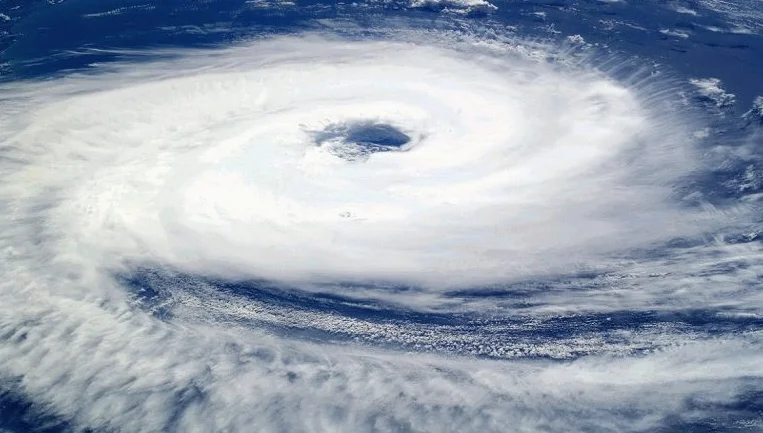
Severe Tropical Cyclone Narelle made landfall in Far North Queensland on Friday, March 20, 2026, bringing Category 4 winds and causing widespread power outages across remote regions. The storm, which had reached a peak intensity with wind gusts of up to 270 km/h, hit the Cape York Peninsula, a sparsely populated area known for its fragile infrastructure. As it moved inland, the system was downgraded to Category 2, but its impact on local communities remains severe, with emergency services on high alert for flash flooding and further threats.
Impact on Power Supply and Infrastructure
Queensland authorities confirmed that hundreds of power outages occurred in the wake of Cyclone Narelle’s landfall. The remote town of Coen and surrounding areas in the Cook Shire were among the hardest hit, with residents reporting prolonged darkness and loss of essential services. Power crews have been deployed to the region, but officials have warned that recovery efforts cannot begin until the storm has fully passed. The Australian Energy Market Operator reported that over 1,200 homes were affected by the outages, with some areas experiencing complete blackouts.
The storm’s eyewall crossed the coast approximately 75 km south of Lockhart River, a region that had already been under strict evacuation warnings. Emergency services were stretched thin, with rescue teams, including ambulances and power crews, pre-positioned in anticipation of the storm’s arrival. Queensland Premier David Crisafulli emphasized that while teams were ready to respond, the recovery process would be slow due to the remote nature of the affected areas.
Residents Take Precautionary Measures
In the hours leading up to the storm’s arrival, residents in the path of Cyclone Narelle took extreme measures to ensure their safety. Families in remote cattle stations and Aboriginal communities sought refuge in shipping containers, WWII-era bunkers, and reinforced brick buildings. The Mapoon Local Disaster Management Group issued an ‘Emergency Alert’ on Friday morning, urging residents to stay indoors and avoid roads to prevent further risk.
Local media reported that many residents had been preparing for the storm for weeks, given the increasing frequency of extreme weather events in the region. Some communities had been using sandbags and reinforced structures to protect homes from potential flooding. Despite these precautions, the storm’s intensity left many without access to clean water or electricity for days after its passage.
Cyclone Narelle’s rapid intensification was attributed to record-breaking ocean temperatures in the Coral Sea. According to the Bureau of Meteorology, the sea surface temperatures had reached 31.5°C, the highest recorded in the region for this time of year. This provided the necessary atmospheric ‘fuel’ for the storm to reach Category 5 status briefly before making landfall as a Category 4 system.
Climate Change and Increasing Storm Intensity
Cyclone Narelle is the latest in a series of severe weather events affecting Australia in early 2026. Climate scientists have noted a concerning trend in the Coral Sea, which experienced its hottest summer on record. This has led to more frequent and intense tropical cyclones, as warmer waters provide the energy needed for such systems to form and strengthen rapidly.
According to the Australian Climate Change Centre, the frequency of Category 4 and 5 cyclones has increased by 30% over the past decade. This trend is expected to continue as global temperatures rise, putting more pressure on emergency services and infrastructure in vulnerable regions.
Dr. Emily Lang, a climate scientist at the University of Queensland, stated that the rapid intensification of Cyclone Narelle was not just a one-off event. ‘We have seen a pattern of more powerful cyclones hitting Australia in recent years, and this is directly linked to rising ocean temperatures and climate change,’ she said. ‘The implications for communities in Far North Queensland are significant, as they are now facing more frequent and severe weather events.’
The impact of Cyclone Narelle extends beyond the immediate damage caused by the storm. Communities in the affected areas are now re-evaluating their disaster preparedness plans, with some calling for increased investment in resilient infrastructure and early warning systems. Local leaders have also urged the federal government to allocate more resources to support recovery efforts and long-term climate adaptation strategies.
As the storm moves toward the Gulf of Carpentaria, officials remain on high alert for potential re-intensification over open waters. Emergency services have issued warnings about the possibility of flash flooding in low-lying areas and have advised residents to remain cautious in the coming days. The situation remains fluid, with further updates expected in the next 48 hours.
With Cyclone Narelle now a Category 2 system, the immediate danger has passed, but the long-term effects on the region’s infrastructure and communities will be felt for months to come. The storm has once again highlighted the growing risks posed by climate change and the need for more strong emergency response strategies in vulnerable areas.


Comments
No comments yet
Be the first to share your thoughts